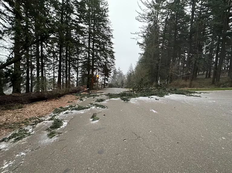
The National Weather Service issued multiple tornado watches throughout Oregon as a severe storm outbreak hit the Portland metro area on Monday night, February 24th. It brought damaging winds with gusts of up to 50 mph, along with heavy rain, lightning, and thunder, causing widespread power outages and downed trees and branches. The weather service issued a wind advisory in Portland, Vancouver Metro, Clackamas, and Central and Southern Willamette Valley.
According to oregonlive.com, “Portland General Electric reported more than 300 outages across Multnomah, Washington, and Clackamas counties, affecting more than 20,000 residents by 5 p.m.” The Portland National Weather Service sent out a total of 15 weather alerts: 10 severe thunderstorm warnings and five tornado warnings. The warning was issued based on radar indicating rotation. The tornado watch was issued so that residents could be prepared and stay informed in case a tornado warning was issued.
Lately, tornadoes have increased due to climate change warming the planet. It leads to a more unstable atmosphere, with increased moisture and the potential for stronger thunderstorms that can produce tornadoes. The last tornado to occur in Portland was on April 5, 1972, when a deadly F3 tornado caused by an intense squall line struck the Portland, Oregon, and Vancouver, Washington metropolitan areas, causing significant damage and injuries—severe damage, including walls collapsing and roofs wholly removed by wind speeds between 158 and 206 mph. The tornado resulted in six deaths and injured 300 people, including 70 students at Peter S. Ogden Elementary School. The 1972 tornado was the deadliest in Washington’s history and the first F3 tornado in Oregon since June 3, 1894. The most recent tornado in Oregon occurred in Rockaway Beach on Monday night, November 11th, 2024. The tornado was classified as an EF-0 on the Enhanced Fujita Scale. Kgw.com said it hit at 9:24 PM and lasted for about one or two minutes. The National Weather Service estimated the wind speeds to be approximately 85 mph. The tornado caused minor damages and injuries to one person, including more than $150,000 in damage at the Neah-Kah-Nie School District’s main office. Cottage Grove Sentinel stated that the tornado likely formed as a waterspout over the ocean and then made landfall, though the path was not continuous.
Peak tornado season has begun, which means it’s time to prepare. Before a tornado, you must stay informed, identify a safe room, prepare for a possible long-term stay, and help minimize potential damage. To stay informed, monitor local TV, radio, or NOAA Weather Radio for warnings. The safest place during a tornado is in the interior part of a basement, a storm cellar, or a small interior room on the lowest level of the building. Gather emergency supplies, including non-perishable foods, water, lanterns in case power goes out, medical supplies, and medication. Fill up a bath with water for drinking water in case you lose water. Trim trees and collect loose items around your home. Bring in outdoor furniture. During a tornado warning, seek shelter immediately, protect yourself, and stay indoors. Go to your designated safe room or the nearest safe location. Stay away from windows, doors, and outside walls. Crouch down and protect your head. Avoid sheds and small shelters. Pause water-based activities like showers, baths, or washing dishes.